From Raw Acreage to Ready-to-Build: The Land Development Process in San Antonio, Texas
San Antonio does not grow like most cities. It does not creep outward in a single direction or concentrate all its energy in one corridor. It expands in multiple directions simultaneously—northwest along Interstate 10 toward Helotes and Leon Valley, north along US 281 toward Stone Oak and Bulverde, east into Converse and Schertz, and south along the Brooks redevelopment corridor that has already surpassed $1.79 billion in completed development on what was once a decommissioned Air Force base. At the same time, the urban core is being rebuilt from the inside, with historic structures being converted into apartments, new transit corridors being planned, and a multi-billion-dollar sports and entertainment district being designed around the existing Alamodome footprint.
Behind every single one of those projects — from a 300-lot master-planned subdivision in the northern ETJ to a mixed-use adaptive reuse project downtown — sits the same invisible infrastructure: land development services. The surveys, the civil engineering, the platting applications, the stormwater management plans, the utility coordination, the zoning cases, the agency submissions, and the construction oversight that collectively transform raw land into something that can legally be built on, sold, and occupied. None of it is glamorous. All of it is essential.
This guide explains what land development services in San Antonio actually involve, why local expertise matters more here than in most markets, and what any serious developer or land investor needs to understand before committing capital to a project in Bexar County.
Why San Antonio’s Regulatory Environment Is Unlike Any Other Texas Market
Texas is broadly understood as a development-friendly state, and that reputation is not unearned. But it can give investors and developers new to the San Antonio market a false sense of simplicity that evaporates quickly once a project is actually underway. The city’s regulatory structure is layered in ways that are specific to this geography, this government structure, and this region’s particular environmental sensitivities.
The City of San Antonio’s Development Services Department is the primary agency for land development review within incorporated city limits. It oversees zoning, platting, master development plans, tree preservation, traffic impact analysis, infrastructure approvals, and building permits, all of which funnel through the department’s BuildSA portal for applications and tracking. Getting familiar with this system early is not optional — it is the central clearinghouse for nearly every approval a development project needs within city limits, and understanding its review timelines and documentation expectations shapes how a project is scheduled from day one.
The Extraterritorial Jurisdiction adds a layer of complexity that surprises many developers unfamiliar with Texas municipal law. San Antonio’s ETJ extends up to five miles beyond the city’s incorporated boundary and covers unincorporated land in Bexar County that is not inside another municipality’s limits or ETJ. Within this zone, the city can review and approve subdivision plats, and land that petitions for future annexation must meet city infrastructure standards. However, zoning authority does not extend into the ETJ — meaning a parcel sitting in unincorporated Bexar County three miles from the city boundary can be subdivided and platted under San Antonio’s review, but it carries no zoning classification. That distinction matters enormously for land use planning and future marketability.
Beyond city and ETJ authority, two environmental regulatory bodies add requirements that are unique to this part of Texas and that no experienced land development services firm ever treats as routine. The Edwards Aquifer Authority governs development over and near the Edwards Aquifer recharge and contributing zones, which cover significant portions of northern Bexar County and beyond. Any project that could affect water quality flowing into the aquifer requires review and often permits from the EAA, including provisions for water quality protection ponds and specific drainage management requirements. The Texas Commission on Environmental Quality enters the picture through its TPDES program, requiring a Construction General Permit and a Stormwater Pollution Prevention Plan for any land disturbance exceeding a threshold acreage. Both of these agencies operate independently from the city’s review process, meaning a project can clear Development Services and still have outstanding agency submittals that prevent construction from starting.
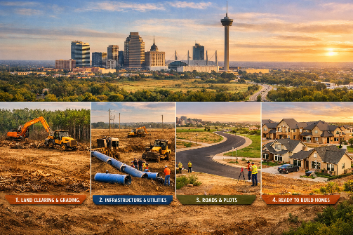
The Service Chain: What Professional Land Development Actually Looks Like
When a developer engages a land development services firm in San Antonio, they are typically engaging access to multiple disciplines that need to operate in a specific sequence. Understanding that sequence is the difference between a project that moves efficiently through entitlement and one that cycles back through review multiple times at significant cost.
Surveying is where the technical process starts. A boundary survey establishes exactly what a property owner controls and where the edges of that control lie, which matters far more than most buyers realize until a discrepancy surfaces mid-project. A topographic survey captures existing elevations across the site — the data foundation for every drainage calculation, road alignment decision, and grading plan that follows. For projects with lenders or institutional investors, an ALTA/NSPS survey is typically required to meet title insurance underwriting standards. In San Antonio, the topographic data captured during this phase also informs whether the site has any Edwards Aquifer recharge zone characteristics that will need to be addressed in later design stages.
Geotechnical investigation follows closely and is often undervalued by first-time land buyers. Bexar County’s soils vary considerably. The northern parts of the county sit over Edwards limestone bedrock with thin soil cover and good drainage but difficult utility trenching. Central and southern portions carry the Blackland Prairie’s expansive clay soils, which absorb and release moisture in ways that produce significant ground movement — enough to crack foundations and damage underground infrastructure if not properly accounted for during structural and civil design. A geotechnical report from a firm with local experience in the specific area of a site is not a formality. It directly drives foundation type selection, pavement section thickness, and utility installation methods.
Civil engineering is the technical core of land development. In San Antonio, a full civil package for a development project typically includes a drainage and grading plan, water and sewer utility design, paving and geometric layout for internal streets, and all documentation required by the city or county for plan review. The drainage component deserves particular attention. San Antonio and the broader Bexar County area fall within one of the most flash-flood-prone regions in the United States, and local drainage ordinances reflect that reality seriously. Downstream peak flow protection requires that post-development runoff not exceed pre-development conditions for the design storm event, which almost always means designing on-site detention or retention facilities. Sizing these facilities correctly, positioning them to preserve usable land area, and designing them to meet the specific requirements of the reviewing jurisdiction — which can vary between the city, the county, and the San Antonio River Authority — requires engineers who have genuinely worked through these calculations in this specific context, not just in Texas generally.
Platting is the formal process of dividing land into legally recognizable lots and recording the resulting plat document in the public record. In San Antonio, this is a prerequisite for obtaining building permits — you cannot get a permit for a structure on a lot that has not been properly platted. The platting process takes different forms depending on what is being done to the land. A minor plat handles simple divisions of a small number of lots when no new public infrastructure is required. A major plat applies to larger subdivisions where roads, utilities, and easements must be formally established. A replat modifies a previously recorded plat, which can involve vacating existing lot lines, easements, or building setback lines in ways that require neighbor notification and sometimes public hearings. An amending plat makes minor corrections or adjustments to a recorded plat without triggering the full replat review process. Choosing the right platting approach, and preparing the application package in the form the Planning Commission’s review staff expects, is one of those areas where experienced local firms save project timelines in ways that are hard to quantify until you see how much a poorly prepared application delays a project.
Zoning adds a quasi-political dimension to what is otherwise an engineering and design process. Properties within San Antonio’s city limits must have zoning that permits the intended land use before a building permit will be issued. Properties that are already zoned for the target use can proceed directly to design and platting. Properties that require a zoning change must go through an application, a planning commission hearing, and a city council vote—a process that typically takes several months under the best conditions and can extend considerably if the application attracts neighborhood opposition. Within the broader San Antonio Unified Development Code, certain uses also require a specific use authorization in addition to the base zoning category, adding another review layer for uses like fuel stations, drive-through restaurants, and certain institutional uses even in otherwise commercially zoned districts.
Where the Work Is Actually Happening
Understanding the regulatory environment is one thing. Understanding where the active development pressure is concentrated gives that regulatory knowledge immediate practical application.
The Brooks development on the South Side is one of the most compelling land development stories in the country right now. Formerly Brooke Army Medical Center’s support base and later Brooks Air Force Base, the property has been transformed over roughly two decades into a mixed-use campus that now houses more than 150 businesses and has recorded over $1.79 billion in completed development, with another $328.6 million in active projects underway. The NRP Group and Brooks broke ground in early 2026 on Lucia at Brooks, a 353-unit residential project that expands housing availability on a part of the city that has historically seen less investment than the northern growth corridors. A proposed data center, solar farm, and battery storage facility are also in discussion for the campus, reflecting the same industrial energy and technology infrastructure investment pattern showing up along the I-35 corridor.
The northern and northwestern growth corridors remain among the most active residential development zones in the entire San Antonio metro area. Master-planned communities along US 281, State Highway 46, and the outer Loop 1604 continue to absorb demand from the city’s expanding population, with infrastructure extension projects — water mains, sewer lift stations, road improvements—running alongside residential subdivision design across multiple concurrent project sites. The Edwards Aquifer recharge zone coverage across parts of this corridor means that land development services firms working here need EAA permitting experience as a standard capability, not a specialty add-on.
Downtown and the urban core are seeing a different kind of land development activity — smaller in footprint but high in complexity. Adaptive reuse of historic structures, infill residential on previously underutilized parcels, and mixed-use projects in transitional neighborhoods all involve platting issues, zoning questions, and sometimes Historic and Design Review Commission oversight that differs significantly from greenfield suburban development. The Zona Cultural area around Market Square, the redevelopment activity on South Alamo Street near Hemisfair, and the Project Marvel footprint along César Chávez Boulevard all represent live development and public infrastructure investment that creates opportunities for private projects in adjacent blocks — but navigating those opportunities requires knowing how the public and private approval processes interact in these specific districts.
What the Right Land Development Partner Actually Delivers
There is a distinction that separates commodity land development services from the kind of professional support that materially affects how a project performs financially and on schedule. The commodity version handles applications and produces drawings. The better version anticipates what each reviewing agency will ask before an application is submitted, structures the project phasing to minimize carrying costs during entitlement, identifies site characteristics early that would otherwise become expensive surprises during construction, and maintains the working relationships with city staff, EAA engineers, and utility providers that compress review timelines without compromising the quality of the submission.
In a market like San Antonio — where growth is genuine and sustained but where the regulatory layers, environmental sensitivities, and jurisdictional complexity are real — the choice of land development partner is not a procurement exercise. It is a risk management decision. Developers who treat it as one, and who invest in local expertise rather than assuming that competence anywhere in Texas translates to competence in Bexar County specifically, consistently move their projects through entitlement more efficiently and reach the construction phase with fewer unresolved issues hanging over them.
San Antonio’s growth is not slowing down. The land under consideration for development is becoming more complex, not simpler, as the easy suburban acreage gets absorbed and attention turns to sites with more history, more encumbrances, and more regulatory sensitivity. The value of knowing how to work through that complexity, in this city, with these agencies, under these specific conditions, has never been greater.